本文主要是介绍Geojson 海南省数据 带南海诸岛 优化 echarts,希望对大家解决编程问题提供一定的参考价值,需要的开发者们随着小编来一起学习吧!
起因
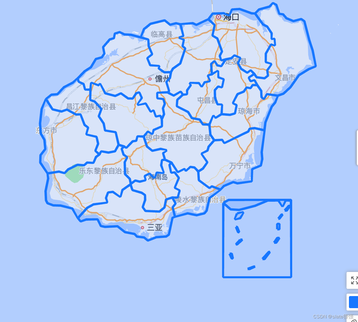
大屏需要用到海南地图,但是三沙市和南海诸岛的空间位置过大,导致图形难看,所以使用了 geo编辑器,自己修改了一下数据。另外搜到 这个文章 ,发现数据都加密了,特此开源。
如果帮助到你,请点赞、投币、一键三连!
公告
如果你还有别的地图需求,或者定制需求可以联系我,如果需求大,我会做一款地图编辑器,可以任意合并、挪动、缩放图形。
源码
{"type": "FeatureCollection","features": [{"type": "Feature","properties": {"adcode": 460100,"name": "海口市","center": [110.33119, 20.031971],"centroid": [110.422966, 19.852113],"childrenNum": 4,"level": "city","parent": {"adcode": 460000},"subFeatureIndex": 0,"acroutes": [100000, 460000]},"geometry": {"type": "MultiPolygon","coordinates": [[[[110.106525, 20.026851],[110.144395, 20.074418],[110.24319, 20.077568],[110.293282, 20.059614],[110.318467, 20.109061],[110.387355, 20.11347],[110.495039, 20.077253],[110.526612, 20.075206],[110.598, 19.98305],[110.634666, 19.965401],[110.675314, 19.907868],[110.676147, 19.860092],[110.699573, 19.861512],[110.704665, 19.805992],[110.670314, 19.812776],[110.623, 19.735461],[110.623463, 19.664109],[110.672814, 19.647214],[110.636148, 19.593989],[110.641333, 19.549122],[110.611518, 19.526841],[110.540223, 19.535532],[110.519297, 19.563341],[110.486705, 19.593357],[110.455687, 19.574559],[110.401151, 19.606626],[110.372633, 19.654004],[110.393373, 19.698053],[110.340041, 19.720625],[110.314208, 19.697421],[110.262449, 19.687318],[110.222357, 19.67974],[110.208468, 19.716679],[110.228283, 19.753767],[110.186246, 19.864193],[110.143932, 19.889106],[110.161895, 19.977693],[110.106525, 20.026851]]]]}},{"type": "Feature","properties": {"adcode": 460200,"name": "三亚市","center": [109.508268, 18.247872],"centroid": [109.421656, 18.362263],"childrenNum": 4,"level": "city","parent": {"adcode": 460000},"subFeatureIndex": 1,"acroutes": [100000, 460000]},"geometry": {"type": "MultiPolygon","coordinates": [[[[108.932374, 18.335288],[109.015243, 18.422645],[109.072557, 18.452231],[109.195148, 18.469407],[109.185056, 18.507095],[109.203574, 18.553517],[109.246537, 18.558921],[109.313295, 18.517429],[109.332832, 18.575451],[109.405146, 18.623443],[109.423386, 18.574657],[109.506163, 18.551291],[109.535237, 18.53142],[109.536996, 18.490717],[109.515607, 18.429008],[109.539866, 18.396713],[109.665883, 18.391462],[109.710882, 18.426462],[109.725234, 18.493102],[109.781159, 18.51107],[109.809955, 18.459388],[109.785048, 18.426622],[109.805418, 18.347543],[109.783381, 18.337516],[109.749863, 18.19326],[109.72616, 18.177808],[109.63792, 18.171595],[109.561718, 18.143554],[109.527366, 18.169046],[109.4632, 18.177171],[109.441349, 18.199153],[109.355887, 18.214922],[109.28811, 18.264925],[109.174686, 18.260149],[109.138668, 18.267791],[109.108298, 18.323828],[109.006632, 18.323032],[108.956448, 18.307433],[108.932374, 18.335288]]]]}},{"type": "Feature","properties": {"adcode": 460400,"name": "儋州市","center": [109.576782, 19.517486],"centroid": [109.390059, 19.579264],"childrenNum": 0,"level": "city","parent": {"adcode": 460000},"subFeatureIndex": 3,"acroutes": [100000, 460000]},"geometry": {"type": "MultiPolygon","coordinates": [[[[108.928671, 19.524313],[108.993392, 19.586723],[109.048576, 19.620051],[109.093668, 19.689844],[109.147649, 19.704998],[109.169501, 19.736724],[109.15913, 19.790689],[109.218574, 19.855834],[109.255611, 19.867189],[109.264592, 19.90503],[109.30811, 19.9178],[109.349591, 19.898724],[109.410794, 19.895256],[109.498663, 19.873339],[109.564588, 19.854888],[109.569218, 19.797947],[109.599402, 19.730726],[109.557366, 19.697421],[109.582921, 19.637581],[109.664216, 19.629685],[109.659402, 19.611048],[109.709308, 19.57756],[109.7694, 19.578508],[109.760048, 19.528895],[109.728197, 19.496023],[109.751993, 19.416974],[109.737734, 19.407486],[109.646439, 19.402425],[109.647272, 19.357505],[109.700234, 19.349436],[109.713382, 19.309881],[109.697271, 19.271267],[109.706808, 19.22156],[109.686994, 19.178965],[109.673105, 19.207627],[109.634031, 19.20256],[109.611995, 19.252589],[109.587365, 19.243249],[109.541625, 19.311939],[109.468386, 19.301178],[109.506348, 19.359561],[109.483848, 19.406063],[109.457275, 19.39942],[109.424405, 19.354815],[109.384035, 19.355448],[109.318943, 19.398155],[109.26774, 19.376803],[109.178389, 19.399262],[109.13052, 19.479584],[109.117557, 19.46757],[109.051447, 19.487803],[109.04478, 19.430415],[108.997373, 19.431522],[108.982744, 19.477213],[108.939596, 19.497287],[108.928671, 19.524313]]]]}},{"type": "Feature","properties": {"adcode": 469001,"name": "五指山市","center": [109.516662, 18.776921],"centroid": [109.511892, 18.824035],"childrenNum": 0,"level": "city","parent": {"adcode": 460000},"subFeatureIndex": 4,"acroutes": [100000, 460000]},"geometry": {"type": "MultiPolygon","coordinates": [[[[109.715419, 18.833686],[109.689216, 18.830036],[109.681531, 18.786071],[109.703012, 18.721769],[109.641809, 18.72304],[109.619865, 18.678252],[109.576717, 18.714782],[109.533662, 18.694295],[109.539866, 18.659508],[109.48857, 18.64664],[109.448293, 18.655378],[109.408016, 18.627733],[109.398109, 18.671104],[109.356628, 18.710653],[109.353387, 18.812896],[109.374591, 18.853998],[109.343109, 18.877163],[109.32635, 18.926338],[109.34848, 18.946321],[109.367739, 18.936171],[109.424775, 18.990403],[109.456349, 18.995635],[109.468386, 19.032254],[109.524033, 19.030986],[109.55357, 18.946321],[109.601532, 18.910318],[109.676531, 18.925862],[109.730512, 18.913649],[109.699123, 18.889379],[109.715419, 18.833686]]]]}},{"type": "Feature","properties": {"adcode": 469002,"name": "琼海市","center": [110.466785, 19.246011],"centroid": [110.421962, 19.210377],"childrenNum": 0,"level": "city","parent": {"adcode": 460000},"subFeatureIndex": 5,"acroutes": [100000, 460000]},"geometry": {"type": "MultiPolygon","coordinates": [[[[110.610593, 19.084394],[110.521797, 19.102932],[110.477539, 19.096912],[110.465039, 19.074411],[110.249949, 18.976292],[110.229579, 19.002452],[110.158562, 18.99944],[110.124118, 19.04747],[110.115229, 19.133191],[110.150876, 19.208419],[110.170598, 19.191317],[110.224857, 19.221718],[110.300226, 19.21586],[110.344392, 19.228368],[110.3593, 19.298646],[110.327356, 19.315261],[110.368744, 19.391829],[110.423928, 19.413495],[110.450317, 19.447492],[110.484761, 19.443223],[110.504853, 19.46836],[110.546242, 19.46836],[110.581426, 19.419504],[110.584111, 19.367787],[110.604574, 19.350386],[110.633555, 19.391354],[110.730035, 19.378859],[110.706517, 19.320167],[110.676703, 19.286302],[110.619296, 19.152041],[110.610593, 19.084394]]]]}},{"type": "Feature","properties": {"adcode": 469005,"name": "文昌市","center": [110.753975, 19.612986],"centroid": [110.788535, 19.747363],"childrenNum": 0,"level": "city","parent": {"adcode": 460000},"subFeatureIndex": 6,"acroutes": [100000, 460000]},"geometry": {"type": "MultiPolygon","coordinates": [[[[110.730035, 19.378859],[110.633555, 19.391354],[110.604574, 19.350386],[110.584111, 19.367787],[110.581426, 19.419504],[110.546242, 19.46836],[110.520594, 19.509931],[110.485779, 19.502345],[110.469854, 19.531424],[110.519297, 19.563341],[110.540223, 19.535532],[110.611518, 19.526841],[110.641333, 19.549122],[110.636148, 19.593989],[110.672814, 19.647214],[110.623463, 19.664109],[110.623, 19.735461],[110.670314, 19.812776],[110.704665, 19.805992],[110.699573, 19.861512],[110.676147, 19.860092],[110.675314, 19.907868],[110.634666, 19.965401],[110.598, 19.98305],[110.526612, 20.075206],[110.56226, 20.109691],[110.655685, 20.134409],[110.687073, 20.16353],[110.717258, 20.148734],[110.744665, 20.073946],[110.778368, 20.068276],[110.808738, 20.035672],[110.871515, 20.011569],[110.940959, 20.028583],[110.969569, 20.010151],[111.013643, 19.850472],[111.044013, 19.763551],[111.071327, 19.628895],[111.008921, 19.60394],[110.920774, 19.552598],[110.844015, 19.450179],[110.781053, 19.395783],[110.730035, 19.378859]]]]}},{"type": "Feature","properties": {"adcode": 469006,"name": "万宁市","center": [110.388793, 18.796216],"centroid": [110.324496, 18.830445],"childrenNum": 0,"level": "city","parent": {"adcode": 460000},"subFeatureIndex": 7,"acroutes": [100000, 460000]},"geometry": {"type": "MultiPolygon","coordinates": [[[[110.158562, 18.99944],[110.229579, 19.002452],[110.249949, 18.976292],[110.465039, 19.074411],[110.477539, 19.096912],[110.521797, 19.102932],[110.610593, 19.084394],[110.585871, 18.897786],[110.590593, 18.839082],[110.577908, 18.784642],[110.500779, 18.752732],[110.495316, 18.649976],[110.36754, 18.632182],[110.329393, 18.642509],[110.246246, 18.609619],[110.213931, 18.578789],[110.137543, 18.606123],[110.115877, 18.592774],[110.020786, 18.658873],[110.014952, 18.732885],[110.057267, 18.758448],[110.095785, 18.811467],[110.045322, 18.884778],[110.097729, 18.911746],[110.108284, 18.944577],[110.158562, 18.99944]]]]}},{"type": "Feature","properties": {"adcode": 469007,"name": "东方市","center": [108.653789, 19.10198],"centroid": [108.818801, 18.996184],"childrenNum": 0,"level": "city","parent": {"adcode": 460000},"subFeatureIndex": 8,"acroutes": [100000, 460000]},"geometry": {"type": "MultiPolygon","coordinates": [[[[109.125242, 18.878432],[109.094965, 18.857012],[109.071076, 18.807499],[109.015151, 18.808928],[108.987003, 18.786547],[108.928578, 18.790198],[108.844412, 18.750827],[108.81145, 18.720022],[108.761543, 18.732091],[108.659785, 18.716846],[108.593212, 18.809404],[108.595619, 18.872086],[108.637841, 18.924593],[108.630434, 19.003086],[108.598305, 19.055869],[108.591082, 19.141587],[108.605712, 19.264619],[108.644785, 19.349278],[108.704136, 19.262719],[108.783765, 19.244674],[108.833209, 19.25987],[108.916171, 19.218552],[108.954874, 19.218869],[108.99191, 19.13034],[109.022929, 19.107052],[109.008762, 19.050005],[109.098853, 19.028291],[109.113668, 18.969949],[109.089779, 18.909842],[109.125242, 18.878432]]]]}},{"type": "Feature","properties": {"adcode": 469021,"name": "定安县","center": [110.349235, 19.684966],"centroid": [110.312936, 19.483405],"childrenNum": 0,"level": "city","parent": {"adcode": 460000},"subFeatureIndex": 9,"acroutes": [100000, 460000]},"geometry": {"type": "MultiPolygon","coordinates": [[[[110.224857, 19.221718],[110.228098, 19.301969],[110.188283, 19.306242],[110.165691, 19.361459],[110.164487, 19.426146],[110.194024, 19.455871],[110.227727, 19.450654],[110.243005, 19.517675],[110.196339, 19.535374],[110.192172, 19.58925],[110.137266, 19.56034],[110.13134, 19.648003],[110.160784, 19.67153],[110.186524, 19.636791],[110.221616, 19.629843],[110.262449, 19.687318],[110.314208, 19.697421],[110.340041, 19.720625],[110.393373, 19.698053],[110.372633, 19.654004],[110.401151, 19.606626],[110.455687, 19.574559],[110.486705, 19.593357],[110.519297, 19.563341],[110.469854, 19.531424],[110.485779, 19.502345],[110.520594, 19.509931],[110.546242, 19.46836],[110.504853, 19.46836],[110.484761, 19.443223],[110.450317, 19.447492],[110.423928, 19.413495],[110.368744, 19.391829],[110.327356, 19.315261],[110.3593, 19.298646],[110.344392, 19.228368],[110.300226, 19.21586],[110.224857, 19.221718]]]]}},{"type": "Feature","properties": {"adcode": 469022,"name": "屯昌县","center": [110.102773, 19.362916],"centroid": [110.055723, 19.342208],"childrenNum": 0,"level": "city","parent": {"adcode": 460000},"subFeatureIndex": 10,"acroutes": [100000, 460000]},"geometry": {"type": "MultiPolygon","coordinates": [[[[110.115229, 19.133191],[110.057267, 19.134617],[110.026526, 19.17564],[109.957638, 19.188625],[109.923565, 19.239608],[109.822733, 19.289626],[109.826436, 19.343108],[109.876436, 19.386926],[109.912917, 19.391671],[109.914583, 19.42409],[109.94699, 19.468044],[109.938287, 19.485749],[110.020508, 19.485432],[110.045785, 19.456029],[110.072081, 19.492071],[110.119488, 19.503293],[110.101803, 19.54928],[110.137266, 19.56034],[110.192172, 19.58925],[110.196339, 19.535374],[110.243005, 19.517675],[110.227727, 19.450654],[110.194024, 19.455871],[110.164487, 19.426146],[110.165691, 19.361459],[110.188283, 19.306242],[110.228098, 19.301969],[110.224857, 19.221718],[110.170598, 19.191317],[110.150876, 19.208419],[110.115229, 19.133191]]]]}},{"type": "Feature","properties": {"adcode": 469023,"name": "澄迈县","center": [110.007147, 19.737095],"centroid": [109.990417, 19.700201],"childrenNum": 0,"level": "city","parent": {"adcode": 460000},"subFeatureIndex": 11,"acroutes": [100000, 460000]},"geometry": {"type": "MultiPolygon","coordinates": [[[[110.137266, 19.56034],[110.101803, 19.54928],[110.119488, 19.503293],[110.072081, 19.492071],[110.045785, 19.456029],[110.020508, 19.485432],[109.938287, 19.485749],[109.94699, 19.468044],[109.914583, 19.42409],[109.912917, 19.391671],[109.876436, 19.386926],[109.857269, 19.412388],[109.793474, 19.379966],[109.737734, 19.407486],[109.751993, 19.416974],[109.728197, 19.496023],[109.760048, 19.528895],[109.7694, 19.578508],[109.786437, 19.608047],[109.852732, 19.652582],[109.897084, 19.77933],[109.874306, 19.799524],[109.884121, 19.853311],[109.842269, 19.871446],[109.879491, 19.885322],[109.855047, 19.984153],[109.965231, 19.993608],[109.997638, 19.979899],[110.106525, 20.026851],[110.161895, 19.977693],[110.143932, 19.889106],[110.186246, 19.864193],[110.228283, 19.753767],[110.208468, 19.716679],[110.222357, 19.67974],[110.262449, 19.687318],[110.221616, 19.629843],[110.186524, 19.636791],[110.160784, 19.67153],[110.13134, 19.648003],[110.137266, 19.56034]]]]}},{"type": "Feature","properties": {"adcode": 469024,"name": "临高县","center": [109.687697, 19.908293],"centroid": [109.71548, 19.809704],"childrenNum": 0,"level": "city","parent": {"adcode": 460000},"subFeatureIndex": 12,"acroutes": [100000, 460000]},"geometry": {"type": "MultiPolygon","coordinates": [[[[109.855047, 19.984153],[109.879491, 19.885322],[109.842269, 19.871446],[109.884121, 19.853311],[109.874306, 19.799524],[109.897084, 19.77933],[109.852732, 19.652582],[109.786437, 19.608047],[109.7694, 19.578508],[109.709308, 19.57756],[109.659402, 19.611048],[109.664216, 19.629685],[109.582921, 19.637581],[109.557366, 19.697421],[109.599402, 19.730726],[109.569218, 19.797947],[109.564588, 19.854888],[109.498663, 19.873339],[109.526626, 19.943494],[109.585328, 19.98825],[109.712271, 20.017398],[109.761715, 19.981317],[109.814307, 19.992977],[109.855047, 19.984153]]]]}},{"type": "Feature","properties": {"adcode": 469025,"name": "白沙黎族自治县","center": [109.452606, 19.224584],"centroid": [109.351743, 19.20989],"childrenNum": 0,"level": "city","parent": {"adcode": 460000},"subFeatureIndex": 13,"acroutes": [100000, 460000]},"geometry": {"type": "MultiPolygon","coordinates": [[[[109.298203, 18.960911],[109.271166, 19.067438],[109.177093, 19.083443],[109.163667, 19.14222],[109.120242, 19.203985],[109.142834, 19.265727],[109.08265, 19.328869],[109.043669, 19.342792],[109.04478, 19.430415],[109.051447, 19.487803],[109.117557, 19.46757],[109.13052, 19.479584],[109.178389, 19.399262],[109.26774, 19.376803],[109.318943, 19.398155],[109.384035, 19.355448],[109.424405, 19.354815],[109.457275, 19.39942],[109.483848, 19.406063],[109.506348, 19.359561],[109.468386, 19.301178],[109.541625, 19.311939],[109.587365, 19.243249],[109.611995, 19.252589],[109.634031, 19.20256],[109.673105, 19.207627],[109.686994, 19.178965],[109.687734, 19.118775],[109.613569, 19.086454],[109.601439, 19.053492],[109.561347, 19.072668],[109.524033, 19.030986],[109.468386, 19.032254],[109.456349, 18.995635],[109.424775, 18.990403],[109.367739, 18.936171],[109.34848, 18.946321],[109.298203, 18.960911]]]]}},{"type": "Feature","properties": {"adcode": 469026,"name": "昌江黎族自治县","center": [109.053351, 19.260968],"centroid": [108.993675, 19.226048],"childrenNum": 0,"level": "city","parent": {"adcode": 460000},"subFeatureIndex": 14,"acroutes": [100000, 460000]},"geometry": {"type": "MultiPolygon","coordinates": [[[[109.04478, 19.430415],[109.043669, 19.342792],[109.08265, 19.328869],[109.142834, 19.265727],[109.120242, 19.203985],[109.163667, 19.14222],[109.177093, 19.083443],[109.271166, 19.067438],[109.298203, 18.960911],[109.265518, 18.905877],[109.206722, 18.894772],[109.141816, 18.904449],[109.125242, 18.878432],[109.089779, 18.909842],[109.113668, 18.969949],[109.098853, 19.028291],[109.008762, 19.050005],[109.022929, 19.107052],[108.99191, 19.13034],[108.954874, 19.218869],[108.916171, 19.218552],[108.833209, 19.25987],[108.783765, 19.244674],[108.704136, 19.262719],[108.644785, 19.349278],[108.694137, 19.387084],[108.747654, 19.391671],[108.806357, 19.450654],[108.887004, 19.4897],[108.928671, 19.524313],[108.939596, 19.497287],[108.982744, 19.477213],[108.997373, 19.431522],[109.04478, 19.430415]]]]}},{"type": "Feature","properties": {"adcode": 469027,"name": "乐东黎族自治县","center": [109.175444, 18.74758],"centroid": [109.029671, 18.639822],"childrenNum": 0,"level": "city","parent": {"adcode": 460000},"subFeatureIndex": 15,"acroutes": [100000, 460000]},"geometry": {"type": "MultiPolygon","coordinates": [[[[109.405146, 18.623443],[109.332832, 18.575451],[109.313295, 18.517429],[109.246537, 18.558921],[109.203574, 18.553517],[109.185056, 18.507095],[109.195148, 18.469407],[109.072557, 18.452231],[109.015243, 18.422645],[108.932374, 18.335288],[108.881264, 18.416599],[108.776728, 18.442051],[108.70997, 18.444119],[108.658304, 18.462728],[108.644971, 18.486741],[108.641082, 18.565279],[108.664137, 18.673328],[108.659785, 18.716846],[108.761543, 18.732091],[108.81145, 18.720022],[108.844412, 18.750827],[108.928578, 18.790198],[108.987003, 18.786547],[109.015151, 18.808928],[109.071076, 18.807499],[109.094965, 18.857012],[109.125242, 18.878432],[109.141816, 18.904449],[109.206722, 18.894772],[109.265518, 18.905877],[109.298203, 18.960911],[109.34848, 18.946321],[109.32635, 18.926338],[109.343109, 18.877163],[109.374591, 18.853998],[109.353387, 18.812896],[109.356628, 18.710653],[109.398109, 18.671104],[109.408016, 18.627733],[109.405146, 18.623443]]]]}},{"type": "Feature","properties": {"adcode": 469028,"name": "陵水黎族自治县","center": [110.037218, 18.505006],"centroid": [109.951436, 18.549546],"childrenNum": 0,"level": "city","parent": {"adcode": 460000},"subFeatureIndex": 16,"acroutes": [100000, 460000]},"geometry": {"type": "MultiPolygon","coordinates": [[[[110.014952, 18.732885],[110.020786, 18.658873],[110.115877, 18.592774],[110.137543, 18.606123],[110.213931, 18.578789],[110.116618, 18.506618],[110.090507, 18.399258],[110.070785, 18.376187],[109.999767, 18.359797],[109.919676, 18.375551],[109.805418, 18.347543],[109.785048, 18.426622],[109.809955, 18.459388],[109.781159, 18.51107],[109.828751, 18.511229],[109.846621, 18.57116],[109.804677, 18.594364],[109.839677, 18.67857],[109.802177, 18.725263],[109.771993, 18.723675],[109.756159, 18.788928],[109.773474, 18.809404],[109.830696, 18.728597],[109.891065, 18.754479],[109.902361, 18.739395],[109.94412, 18.771942],[109.980416, 18.76718],[110.014952, 18.732885]]]]}},{"type": "Feature","properties": {"adcode": 469029,"name": "保亭黎族苗族自治县","center": [109.70245, 18.636371],"centroid": [109.650759, 18.589686],"childrenNum": 0,"level": "city","parent": {"adcode": 460000},"subFeatureIndex": 17,"acroutes": [100000, 460000]},"geometry": {"type": "MultiPolygon","coordinates": [[[[109.715419, 18.833686],[109.773474, 18.809404],[109.756159, 18.788928],[109.771993, 18.723675],[109.802177, 18.725263],[109.839677, 18.67857],[109.804677, 18.594364],[109.846621, 18.57116],[109.828751, 18.511229],[109.781159, 18.51107],[109.725234, 18.493102],[109.710882, 18.426462],[109.665883, 18.391462],[109.539866, 18.396713],[109.515607, 18.429008],[109.536996, 18.490717],[109.535237, 18.53142],[109.506163, 18.551291],[109.423386, 18.574657],[109.405146, 18.623443],[109.408016, 18.627733],[109.448293, 18.655378],[109.48857, 18.64664],[109.539866, 18.659508],[109.533662, 18.694295],[109.576717, 18.714782],[109.619865, 18.678252],[109.641809, 18.72304],[109.703012, 18.721769],[109.681531, 18.786071],[109.689216, 18.830036],[109.715419, 18.833686]]]]}},{"type": "Feature","properties": {"adcode": 469030,"name": "琼中黎族苗族自治县","center": [109.839996, 19.03557],"centroid": [109.854584, 19.033919],"childrenNum": 0,"level": "city","parent": {"adcode": 460000},"subFeatureIndex": 18,"acroutes": [100000, 460000]},"geometry": {"type": "MultiPolygon","coordinates": [[[[109.876436, 19.386926],[109.826436, 19.343108],[109.822733, 19.289626],[109.923565, 19.239608],[109.957638, 19.188625],[110.026526, 19.17564],[110.057267, 19.134617],[110.115229, 19.133191],[110.124118, 19.04747],[110.158562, 18.99944],[110.108284, 18.944577],[110.097729, 18.911746],[110.045322, 18.884778],[110.095785, 18.811467],[110.057267, 18.758448],[110.014952, 18.732885],[109.980416, 18.76718],[109.94412, 18.771942],[109.902361, 18.739395],[109.891065, 18.754479],[109.830696, 18.728597],[109.773474, 18.809404],[109.715419, 18.833686],[109.699123, 18.889379],[109.730512, 18.913649],[109.676531, 18.925862],[109.601532, 18.910318],[109.55357, 18.946321],[109.524033, 19.030986],[109.561347, 19.072668],[109.601439, 19.053492],[109.613569, 19.086454],[109.687734, 19.118775],[109.686994, 19.178965],[109.706808, 19.22156],[109.697271, 19.271267],[109.713382, 19.309881],[109.700234, 19.349436],[109.647272, 19.357505],[109.646439, 19.402425],[109.737734, 19.407486],[109.793474, 19.379966],[109.857269, 19.412388],[109.876436, 19.386926]]]]}},{"type": "Feature","properties": {"name": "南海诸岛","latitude": 18.49,"longitude": 110.24,"parent": {"adcode": 460000},"subFeatureIndex": 19,"adcode": 460300,
"center": [
110.54882,
18.231039
],
"centroid": [
110.54882,
18.231039
],
"acroutes": [
100000,
460000
]},"geometry": {"type": "MultiPolygon","coordinates": [[[[110.24,18.465],[110.28761904761905,18.49],[110.84952380952382,18.49],[110.84952380952382,18.485],[110.80190476190477,18.485],[110.77333333333334,18.435],[110.7352380952381,18.485],[110.64,18.485],[110.52571428571429,18.439999999999998],[110.38285714285715,18.404999999999998],[110.30666666666667,18.409999999999997],[110.24,18.465]]],[[[110.36380952380952,18.375],[110.42095238095239,18.384999999999998],[110.39238095238095,18.334999999999997],[110.34476190476191,18.325],[110.36380952380952,18.375]]],[[[110.35428571428571,18.259999999999998],[110.36380952380952,18.259999999999998],[110.38285714285715,18.215],[110.37333333333333,18.215],[110.35428571428571,18.259999999999998]]],[[[110.39238095238095,18.15],[110.41142857142857,18.15],[110.36380952380952,18.11],[110.35428571428571,18.11],[110.39238095238095,18.15]]],[[[110.29714285714286,18.029999999999998],[110.31619047619047,18.029999999999998],[110.32571428571428,17.99],[110.31619047619047,17.99],[110.29714285714286,18.029999999999998]]],[[[110.45904761904762,17.9],[110.51619047619047,17.919999999999998],[110.52571428571429,17.919999999999998],[110.47809523809524,17.9],[110.45904761904762,17.9]]],[[[110.59238095238095,17.985],[110.64952380952381,18.044999999999998],[110.65904761904763,18.044999999999998],[110.61142857142858,17.985],[110.59238095238095,17.985]]],[[[110.69714285714286,18.125],[110.72571428571429,18.165],[110.7447619047619,18.165],[110.71619047619048,18.125],[110.69714285714286,18.125]]],[[[110.72571428571429,18.24],[110.72571428571429,18.284999999999997],[110.7447619047619,18.284999999999997],[110.7447619047619,18.24],[110.72571428571429,18.24]]],[[[110.7352380952381,18.33],[110.76380952380953,18.365],[110.77333333333334,18.365],[110.7447619047619,18.33],[110.7352380952381,18.33]]],[[[110.79238095238095,18.4],[110.83047619047619,18.439999999999998],[110.84,18.439999999999998],[110.81142857142858,18.4],[110.79238095238095,18.4]]],[[[110.24,18.465],[110.24,17.83],[110.84952380952382,17.83],[110.84952380952382,18.49],[110.84952380952382,18.49],[110.84952380952382,17.83],[110.24,17.83],[110.24,18.465],[110.24,18.465]]]]}
}]
}
这篇关于Geojson 海南省数据 带南海诸岛 优化 echarts的文章就介绍到这儿,希望我们推荐的文章对编程师们有所帮助!


